boat

The benchmark for inland navigation

Navigis River has been the standard for inland navigation for many years. The reason for this is the simplicity and user-friendliness of its sophisticated navigation technology.

The vessel’s GPS position is displayed on a navigational chart. While the vessel remains in a fixed position, the chart moves under the vessel, similar to a radar image. You can see everything you need for navigation with just a simple mouse click. Other data such as your course, speed, and VHF channels are shown in separate windows, giving you extra assistance to ensure smoother and safer navigation.

With its many optional extras, Navigis can be upgraded from a navigation programme to an all-inclusive navigation manager to include itineraries, voyage reporting, eMessaging, etc.


25441214-kompasnaald-wijst-op-de-blauwe-tekst-blauwe-en-zwarte-tinten-met-blur-effect-en-focus-op-de-belangri

International certification

Navigis has been developed in accordance with the latest Inland ECDIS standards of the CCNR and the Danube Commission. With the approval of its RadarLink by FVT (Fachstelle der WSV für Verkehrstechniken, certificate no. R-4-102), Tresco has become the world’s first company to offer ECDIS-certified navigation systems for both inland and maritime navigation.

map

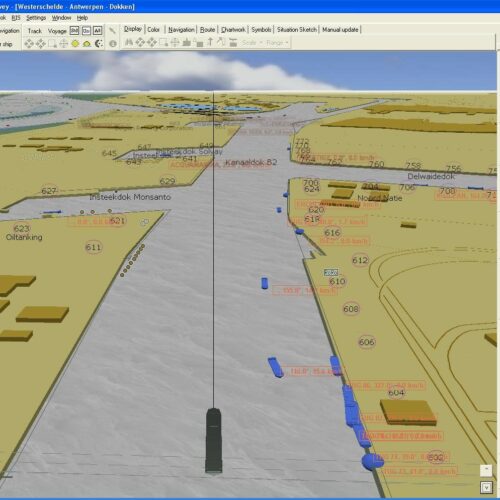
Realistic 3D display

A 3D image that stretches all the way to the horizon, with large objects passing by clearly. Navigis now also has a 3D map image, which until recently was only used for car navigation systems. Its advantages are the same as with car navigation: it provides a realistic image of the immediate surroundings, with objects nearby being more clearly visible than those in the distance. If desired, you can go back to the classic Navigis 2D image with a single click.

eygduye2

Additional features and options

  • AIS (for identification of nearby vessels)
  • Itinerary (with relevant data about what to expect along the way)
  • RIS (for real-time water levels and messaging)
  • Electronic compass or second GPS/DGPS
  • Conning Display
  • RadarLink
icon15

Online connected, always informed

Today’s mobile internet, with faster connections, larger data bundles, and reliable connection, is an essential feature of the modern wheelhouse. Real-time water levels, online updates, aerial photography, real-time berthing data: these are just some of the many internet-based features in Navigis.

icon16

RIS: Real-time water levels and messaging

Connect Navigis to the Tresco RIS server to receive data on water levels in real time or for a specific period. The water levels will then be processed automatically on the charts. Standard shipping traffic data such as disruptions, delays, and meteorological information will also appear in detail on the screen.

icon17

AIS: Identification of nearby vessels

AIS provides added value for navigational safety on rivers and seas. Therefore, the onboard AIS transponder can also be connected to Navigis.

References